
Confined spaces such as tunnels, mines, and underground utility galleries are classic "positioning black holes." GNSS signals cannot penetrate rock, soil, or concrete structures, while solutions like Wi-Fi and UWB—which rely on pre-deployed infrastructure—are often impractical for emergency scenarios or long-distance tunnels. Inertial Navigation Systems (INS), characterized by their complete autonomy and independence from external signals, have emerged as the core positioning technology for underground robots.
An inertial navigation system consists of a three-axis accelerometer and a three-axis gyroscope. Its fundamental positioning principle involves integrating kinematic equations:

An accelerometer measures the specific force acting on a vehicle; after compensating for gravity, the acceleration is obtained. A gyroscope measures angular velocity, which is used to update the attitude matrix, allowing the acceleration to be transformed into the navigation coordinate system. However, any minute sensor bias will accumulate over time, growing quadratically:
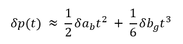
Here, $\delta a_b$ represents the accelerometer bias, and $\delta b_g$ represents the gyroscope bias. These can lead to errors of tens of meters within just a few minutes.
The movement of walking robots or wheeled mobile robots is characterized by periodic pauses—moments when a foot makes contact with the ground or a wheel comes to a complete stop—during which the actual velocity of the platform is zero. Zero Velocity Update (ZUPT) leverages this constraint to periodically correct errors in inertial navigation.
Detection Logic: The variance of the acceleration and the magnitude of the angular velocity are monitored in real time. If these values remain below a specific threshold for a consecutive number of sampling points, the system is determined to be in a stationary state.

Update method: Velocity observations obtained during periods of stillness are set to zero and used as measurement updates for an Extended Kalman Filter (EKF) to estimate and compensate for gyroscope biases, accelerometer biases, and attitude errors.
The EKF serves as the standard fusion framework for inertial navigation-based ZUPT (Zero-Velocity Update) schemes, with a state vector that includes position, velocity, attitude quaternions, and sensor errors:

Prediction step: Using raw IMU data as input, propagate the state via inertial navigation mechanization:

Update step: When ZUPT detects a stationary state, construct the velocity observation equation

calculate the Kalman gain, and update the state and covariance matrix.
In actual underground coal mine deployments, a miniature inertial navigation system (INS) based on the aforementioned approach achieved 8 hours of continuous autonomous excavation with a positioning error of less than 5 centimeters. This result effectively validates the engineering feasibility of using a pure inertial navigation system in enclosed environments over extended durations. In a test conducted along a ~200-meter route within a utility tunnel, a hybrid approach—combining inertial navigation with map-based corrections—limited the terminal deviation to the order of 0.1 meters, with deviations along straight segments generally remaining under 0.2 meters; this highlights the significant role of map constraints in suppressing drift. Furthermore, experiments involving the fusion of visual data and inertial navigation in a tunnel environment demonstrated an approximately 70% improvement in positioning accuracy compared to a vision-only system. This further underscores the core value of inertial navigation as a foundational positioning source within multi-sensor fusion frameworks.
By virtue of its unique advantage—independence from external infrastructure—a pure inertial navigation system serves as a reliable foundation for robot positioning in GPS-denied underground environments. Through the effective integration of Zero-Velocity Update (ZUPT) and the Extended Kalman Filter (EKF), error accumulation can be successfully mitigated during typical pedestrian or wheeled locomotion, thereby supporting critical applications such as mine inspections, utility tunnel exploration, and emergency rescue operations.
leave a message
Scan to Wechat :