
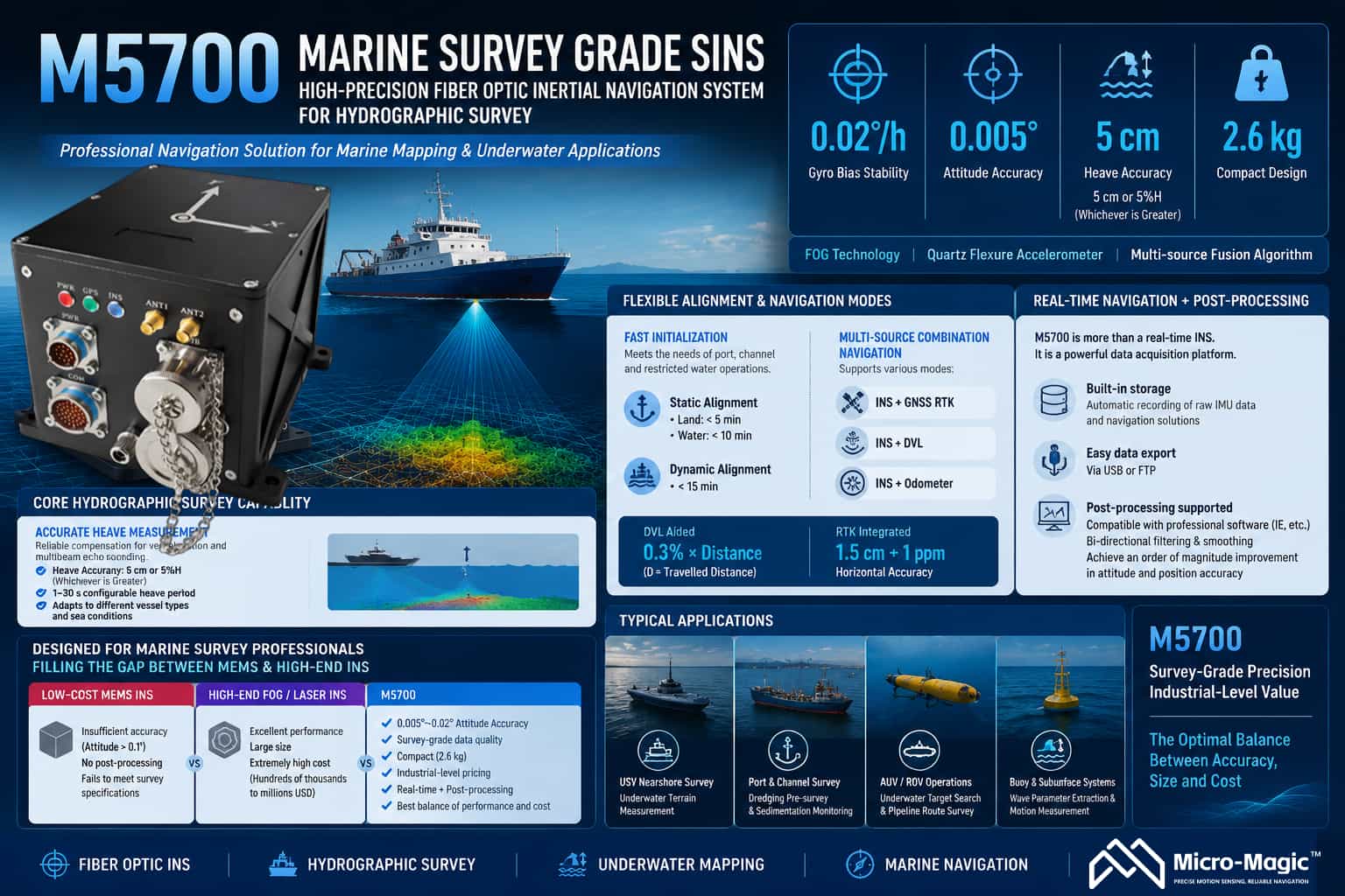
The M5700 Fiber-Optic Inertial Navigation System is a high-precision strapdown inertial navigation system designed for marine surveying and high-end navigation applications. It integrates fiber-optic gyroscopes, quartz flexure accelerometers, and multi-source fusion navigation algorithms. With a gyroscope bias stability of 0.02°/h and an attitude accuracy of 0.005°, the system establishes a strong technical position in the field of maritime surveying.
**Core Surveying Capabilities**
Heave measurement is a critical requirement in marine surveying. The M5700 offers a heave accuracy of 5 cm or 5% of heave height (whichever is greater), effectively compensating for the impact of vessel motion on multibeam bathymetric data. The system supports configurable heave periods ranging from 1 to 30 seconds, adapting to various sea conditions and vessel characteristics.
Alignment solutions are flexibly adapted to operational scenarios: static base alignment takes less than 5 minutes (on land) and less than 10 minutes (in water), while dynamic base alignment takes less than 15 minutes, meeting the need for rapid operations in restricted waters such as ports and channels.
Multi-source integrated navigation supports various modes, including Inertial/GNSS, Inertial/DVL, and Inertial/Odometer. With DVL assistance, position accuracy reaches 0.3% of distance traveled (D); when integrated with GNSS RTK, horizontal accuracy reaches 1.5 cm + 1 ppm, ensuring navigation continuity during GNSS signal outages.
**Post-processing Capabilities**
Post-processing capability is a key differentiator that sets the M5700 apart from purely real-time navigation products. The system features built-in storage, automatically recording raw IMU data and navigation solutions upon power-up, which users can easily export via USB or FTP. The stored IMU data can be directly imported into professional post-processing software (such as IE) for bidirectional filtering and smoothing, yielding attitude and position accuracy an order of magnitude better than real-time solutions. This capability allows the M5700 to serve not only real-time operations but also as a data acquisition front-end, providing the raw data foundation for refined processing and meeting the rigorous accuracy requirements of applications such as hydrographic surveying and underwater terrain modeling. Market Positioning
The M5700 is precisely positioned for the mid-range marine surveying and mapping market. Its core clientele includes hydrographic bureaus, maritime safety administrations, waterway authorities, marine geological survey agencies, and manufacturers of unmanned surface vessels (USVs) and ROVs.
The current market is sharply polarized: low-end MEMS products lack sufficient accuracy (attitude >0.1°) and lack post-processing capabilities, failing to meet surveying standards; conversely, high-end fiber-optic or laser-based inertial navigation systems offer superior performance but are bulky and prohibitively expensive (ranging from hundreds of thousands to over a million RMB), exceeding the budgets of most commercial projects. Built around fiber-optic gyroscope technology, the M5700 delivers genuine survey-grade data with attitude accuracy in the 0.005°–0.02° range. It combines a compact 2.6 kg design and industrial-grade pricing with dual-mode output (real-time navigation and post-processing), effectively filling this market gap.
Typical applications include nearshore underwater topographic surveying using small-to-medium USVs; pre-dredging sweeps and siltation monitoring in port channels using manned vessels; underwater target searches and pipeline route surveys using AUVs/ROVs; and wave parameter extraction for buoy and subsurface mooring systems. The M5700 enables professional users to obtain attitude and heave data that strictly comply with surveying standards within a limited budget, making it the optimal solution for balancing performance and cost in marine surveying projects.
leave a message
Scan to Wechat :