
The New Era of High-Precision Positioning: Deep Integration of RTK Technology and the I3700 Dual-Antenna GNSS/INS System


Author
21221
In the quest for the ultimate relaxation experience, our sofas are designed with your well-being in mind. Every curve and cushion is engineered to support and embrace your body's contours, creating a sense of comfort that feels tailor-made. We delve deep into the science of seating to ensure that with every moment you spend on our sofas, you feel the world melt away. Build all at once or add on over time. If you change your space, you can always change the shape.
Marie R. Winters


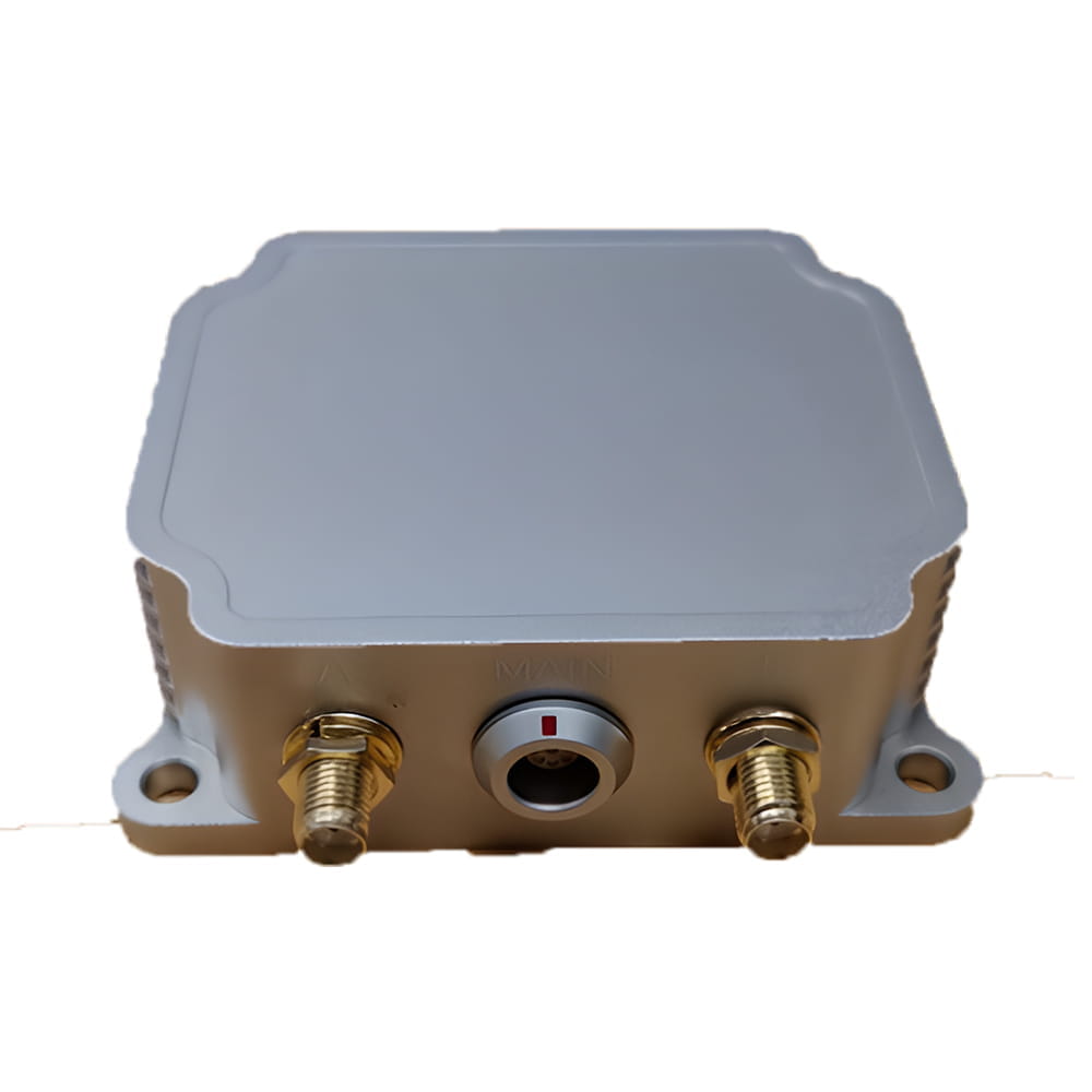
Centimeter-level real-time positioning is crucial in fields like autonomous driving, precision agriculture, and drone surveying. Micro-Magic's I3700 Dual-Antenna GNSS/INS system enhances RTK technology by overcoming limitations like signal occlusion, enabling accurate and reliable navigation in complex environments. This system powers next-gen applications with robust positioning.
In digitally driven fields like autonomous driving, precision agriculture, and drone surveying, centimeter-level real-time positioning has become a core requirement. Real-Time Kinematic (RTK) technology reduces traditional GPS positioning errors from meters to centimeters through base station-rover collaboration. The emergence of Micro-Magic’s I3700 High-Performance Dual-Antenna GNSS/INS Integrated Navigation System empowers RTK with enhanced environmental adaptability and reliability, ushering in a new era of high-precision positioning.
I. Core Breakthroughs of RTK Technology
The RTK system achieves precision positioning through base station-rover collaboration:
-
Base Station: Positioned at known coordinates, it calculates real-time satellite signal errors (e.g., atmospheric delay, clock drift)
-
Rover: Receives error-correction data from the base station and fuses it with its own observations for centimeter-level positioning
-
Real-Time Performance: Data transmission via 4G/NTRIP protocols with <20ms latency
Technical Bottleneck: Traditional RTK fails under signal occlusion (tunnels, urban canyons) and cannot provide carrier attitude data.
II. I3700 System: The Enhanced Engine for RTK
As a high-performance module integrating dual-antenna GNSS + Inertial Navigation (INS), the I3700 overcomes RTK limitations through three innovations:
1. Dual-Antenna Heading Enhancement
-
Baseline Orientation: A/B antenna spacing: 0.8–1.5m; calibrated against the carrier’s Y-axis using the SETBASELINE command
-
Heading Accuracy: 0.2° (under RTK fixed solution), far exceeding single-antenna GPS (2°–5° error)
-
Anti-Occlusion Capability: Maintains heading during GNSS signal loss using a gyroscope with 2.5°/hr bias stability
2. Multi-Source Fusion Algorithm
# Extended Kalman Filter (EKF) Workflow
while True:
   gnss_data = get_rtk_position()  # Acquire RTK position
   imu_data = read_mems()          # Read MEMS angular velocity/acceleration
   wheel_speed = can_obd2_decode() # Decode CAN bus vehicle speed
   fused_position = ekf_fusion(gnss_data, imu_data, wheel_speed)
-
Supported Peripherals: Odometers, DVL (Doppler Velocity Log), vision sensors
-
Continuous Navigation: Horizontal positioning error <6m within 60s of GNSS loss (with odometer input)
3. Industrial-Grade Reliability Design
| Parameter | Specification | Industry Advantage |
|---|---|---|
| Protection Rating | IP68 waterproof | Farm/nautical muddy environments |
| Temp. Range | -40°C to 85°C | Extreme cold/heat conditions |
| Power Supply | 6–36V wide-voltage DC | Direct vehicle power draw |
| Certification | CE/ROHS | Export compliance |
III. Scenario-Based Application Cases
1. Autonomous Agricultural Machinery
Challenge: Signal occlusion in farmlands causes path deviation during automated operations
I3700 Solution:
Dual antennas provide stable heading, achieving ±2.5cm inter-row navigation with RTK
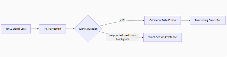
INS maintains <1m error for 10s under tree occlusion
Command: CONFIG MODEL CAR activates vehicle motion constraints
2. Urban Autonomous Driving
-
Key Config: Output 20Hz fused navigation data via LOG INSPVAXB ONTIME 0.05
3. Drone Power Grid Inspection
-
Precision Hovering: 0.8cm+1ppm position accuracy under RTK fixed solution
-
Wind-Resistant Attitude: 150Hz accelerometer compensates crosswind disturbances
-
Data Transmission: RS-422 interface streams binary RAWIMUXB (raw IMU data)
IV. Technical Extension: From Positioning to Spatiotemporal Networks
I3700’s multi-protocol interfaces enable limitless system integration:
-
Cloud Collaboration: Access Qianxun/China Mobile CORS via 4G DTU
CONFIG NTRIP rtk.ntrip.qxwz.com 8002 AUTO qxx 123456 # Qianxun account setup
-
Automotive-Grade Comms: SAE J1939 outputs PGN65341 (attitude)/PGN65345 (heading)
-
Synchronized Triggering: PPS pulse + SYNC_IN pin synchronizes LiDAR scanning
Conclusion: The "Dual-Core Era" of Precision Positioning
RTK solves absolute positioning accuracy, while GNSS/INS systems like I3700 deliver environmental robustness and attitude dimensionality. Together, they form a "spatiotemporal dual-core," bridging the "last centimeter" gap for autonomous driving, smart agriculture, and robotics.
- MG-502 High Precision MEMS Gyroscope: Precision Navigation in Harsh Drilling Environments
- U6488 high-precision MEMS IMU: the core of stable control for drones and intelligent platforms
- Why the MG-502 MEMS Gyroscope is the “Hidden Eye” of Drone Attitude Control
- Applications of Fiber Optic Gyroscope: Enhancing Navigation and Orientation Precision
- The New Era of High-Precision Positioning: Deep Integration of RTK Technology and the I3700 Dual-Antenna GNSS/INS System
- Understanding Fiber Optic Gyroscope: How It Works
- The influence of low-pressure environment on quartz flexible accelerometers: A key consideration in aerospace applications
- Technical Analysis of Inclinometer Tilt: Accurate Measurement, Stable and Reliable